Visualizing San Francisco Bay’s Forgotten Past
Matthew M. Booker
To begin: One question and one metaphor. The question is, what use is visualization to historians? How does this method add value to the work we do? The metaphor is accretion, the term geologists use to describe the building up of new soils through deposits of materials eroded elsewhere. Accretion works to describe the process by which generations have modified San Francisco Bay without destroying that which came before. That history remains, even if it is invisible to the naked eye. Visualization helps us recapture the forgotten past.
Archaeologists see the past as a series of layers. They dig through one past into another. Historians can think in similar terms. Many people in the American West think of nature as timeless and human creations as quite recent, even superficial. The San Francisco Bay is in fact a young land with deep human history. The current bay has only existed for some five thousand years or so, as rising seas flooded river valleys already inhabited by Indian peoples. Their forgotten but not erased past was visible in the hundreds of shellmounds these people raised over the millennia.
But rather than this astonishing story of Indian persistence — adapting to environmental change to inhabit the same places for more than a thousand years! — many Americans think San Francisco Bay’s history began with one of the great geo-engineering events in American history, the California Gold Rush.
The usual story of the Gold Rush is the story of individual miners making their fortune. In fact most miners never did find wealth. Nor was this a story about individuals. Surface gold quickly ran out and the miners with pans gave way to the nation’s most heavily capitalized corporations. Mining companies hired men to dam rivers and use water cannons to wash down the mountains for the gold inside. From the 1860s through the 1880s, hydraulic miners washed more soil, sand, and gravel out of California’s Sierra Nevada Mountains than all of the earth ever excavated from the Panama Canal. This soil filled parts of San Francisco Bay by more than a meter. The gold rush also spurred another, lesser known mining industry, one that flowed in the opposite direction.
Beginning in the 1850s, salt miners converted much of south San Francisco Bay’s tidal marsh and wetlands into evaporative salt ponds. Salt miners adapted an ancient method to industrial production. The ancient part was the steady ocean wind evaporating water and leaving salt behind. The industrial part was the use of windmills, later electric pumps and bulldozers to move the brine through a series of pools and to produce millions of tons of sea salt each year.

South San Francisco Bay Salt Ponds, 1857-1931.
Salt was and remains one of the most important mining industries in California. Indeed by volume and by value salt often surpassed gold. By the 1930s salt mining was among the largest land uses in the San Francisco Bay region.
Only a tiny fraction of this salt went to preserve food, such as in the canneries of the Sacramento Delta where generations of Asian and later Mexican workers packed asparagus for the world market. Most salt went to mines in the mountains where it leached gold and silver from rock, to chemical plants to make bleaching agents for the paper mills of the Pacific Northwest, to Western oil refineries to make gasoline, to water treatment plants for the West’s burgeoning cities, and to make napalm jelly for the war in Vietnam.
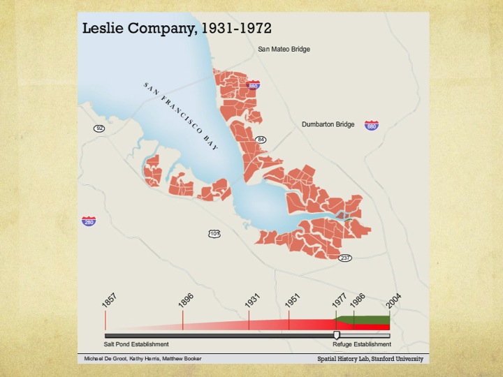
Leslie Salt Company Ponds, 1931-1970s
Here too what began as a family business rapidly became a corporate endeavor, then a monopoly as one company, Leslie Salt, bought up all the others and converted almost the entire shoreline of the bay south of San Francisco into vast stagnant pools walled off from the tides of the bay.
When salt companies converted the marshes and beaches of the bay into salt ponds they destroyed other uses of the edge. During the nineteenth century, the margin of San Francisco Bay was a public space, a place where people picnicked, played, rested, made love — and where thousands of people hunted, fished, and foraged for food. These uses depended on the bay remaining a commons, a shared space open to all. The mudflats and marshes were not just ideal locations to build salt mines. They were also the bay’s nursery for young fish and crabs, the most important links in the Pacific flyway hosting millions of ducks and geese each year, and vast factories for shellfish and shrimp.
In fact some of California’s first commercial fishermen netted bay shrimp, dried them on the shoreline, and then sent dried shrimp powder across the Pacific to China. At least three Chinese shrimping villages survived into the late nineteenth century. Chinese shrimpers were the focus of thirty years of discriminatory state licensing laws, gear and seasonal restrictions, and harassment.
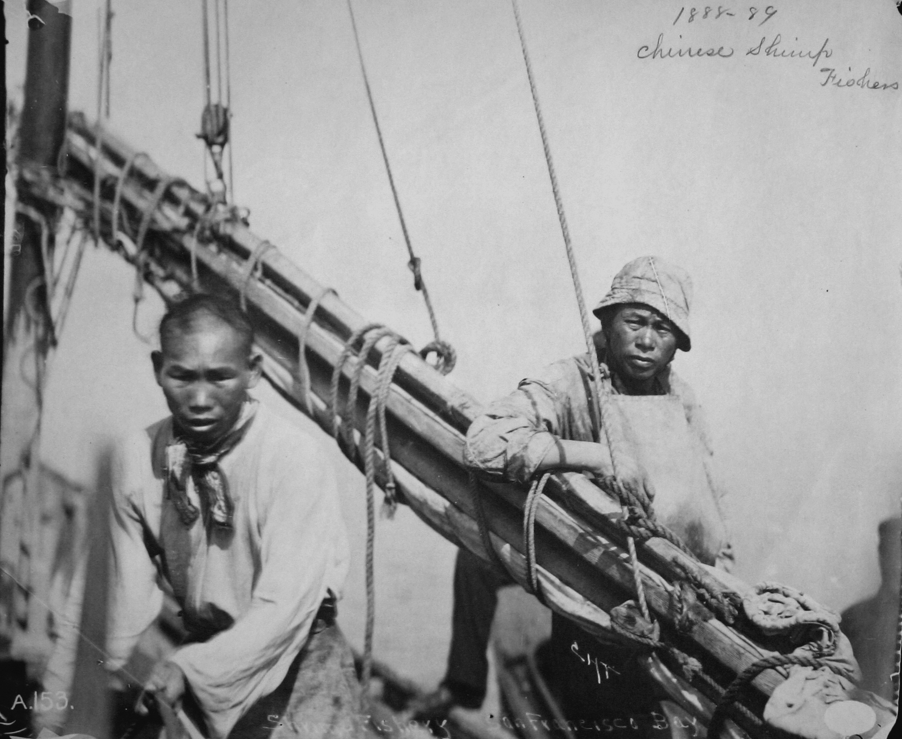
Chinese Shrimp Fishers, San Francisco Bay, circa 1889. National Archives. Courtesy National Oceanic and Atmospheric Administration Historical Fisheries Photograph Collection.
One of the California Fish Patrolmen who would persecute Chinese shrimpers was a young Jack London. Like many policemen, London joined the Fish Patrol after first leading a life of crime. At age 14 he became an oyster pirate to escape a dead-end factory job. He used the lawless spaces of the bay’s edge to find freedom.
Jack London’s writings, snapshots of families on the Berkeley beach, photos of Chinese shrimpers and clam diggers — these sources give tantalizing glimpses into the social world of the working majority in nineteenth century California. Most Californians then and now were city dwellers. Most, like Jack London’s family, were lifelong renters who moved frequently, often to escape debt. For Jack London and for many other common people, the public spaces on the shore were essential to their economic livelihood but also to their sense of personal freedom.
Jack London described factory work as slavery, bondage he got free of only by stealing and selling oysters. London did not see it as stealing. He claimed that the oysters he pirated grew in a public space and were therefore the property of everyone. San Francisco economist, philosopher, and labor leader Henry George spoke for millions of Americans when he argued that monopoly control of land was the greatest threat to the American democracy. But George failed to see it was in the bay and not on land where monopoly was most obvious.
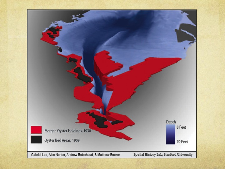
With assistance from graduate and undergraduate students at Stanford University, I mapped the process by which oyster growers first colluded to fix prices, then combined to crush competition, and finally absorbed into a single company with monopoly ownership of all the oyster beds of San Francisco Bay. We found that as the state of California sold its underwater lands to raise money for, among other purposes, the University of California, Morgan Oyster Company bought them up. All of them. Sometimes Morgan did this directly, sometimes with middlemen, and sometimes it simply claimed land that the state never sold.
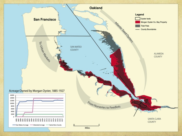
Morgan Oyster Company Holdings, 1885-1930
On the eve of the Great Depression, one company not only dominated production of Atlantic oysters in California, it also controlled all the space where oysters could be grown: the definition of a monopoly.
Monopolizing Oyster Space
Like many monopolies, Morgan did not last long. The company closed in 1930, selling some of its land to cement manufacturers and some to salt miners, who coincidentally were finishing their own period of consolidation into the Leslie Salt Company. Leslie ruled the bay from 1931 to the late 1970s, when they sold their remaining salt ponds to Cargill, a multinational that is one of the world’s largest privately-held corporations. Like the oyster growers, Leslie fenced the public off its tens of thousands of acres.
As Leslie drowned the marshes behind its dikes, one predictable and one very unlikely thing occurred. Predictably, the populations of salt marsh-dependent species in California plunged until a handful of animals and plants were on the verge of extinction. Unexpectedly, however, the salt ponds turned out to be a great habitat for certain species of waterfowl, including ones that people like to hunt. And so for forty years, salt mines fed and sheltered millions of waterfowl. The privatized bayshore was off-limits to hunters, fishers, and foragers, but it was a paradise for ducks.
I want to emphasize that it was an accident that salt ponds fed birds. Leslie was a corporation and it existed to maximize profits. From the beginning, it is clear that Leslie intended to make salt only until some other more profitable use could be found for its ponds. After the Second World War, as the San Francisco Bay Area boomed, Leslie began making plans to fill its salt ponds and build housing developments modeled on the suburban waterways of Florida. At the same time, the shoreline re-entered the public consciousness as conservationists protested the plans to fill in the remaining marshes and citizens groups pointed out that in 200 miles of shoreline, San Francisco Bay had only four miles where the public could actually reach the shore. In 1968 California created a new state agency to manage San Francisco Bay. The Bay Conservation and Development Commission stopped new fill, but it created no new public space.
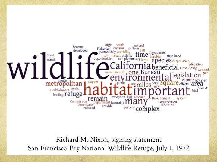
www.wordle.net
That changed in 1972 when Republican Congressman Pete McCloskey got a bill through Congress authorizing the nation’s first urban national wildlife refuge. President Nixon added a signing statement, in which he pointed out that San Francisco Bay was more than a third smaller than it had been in 1850, and that nearly three quarters of the bay’s marshes had been destroyed for housing, industry, airports, and salt mines.
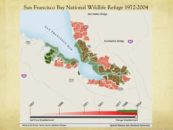
San Francisco Bay National Wildlife Refuge, 1972-2004
Changing ownership had surprisingly little impact on how the salt ponds were managed. The federal government managed the land for a very narrow vision of the public good. The salt ponds were now primarily managed for waterfowl, with some environmental education. Joggers were allowed onto the tops of the dikes, fishers got one hard-to-access pier, and board sailors got a handful of launch points. But no one was allowed to forage, new fences went up, and the margin remained off limits to the broader sense of public that had characterized the nineteenth century.
Then in 2003 Senator Dianne Feinstein announced a deal to purchase most of Cargill’s remaining salt ponds and to double the size of the refuge. It would be one of the largest restoration projects in history. The 2003 acquisition coincided with a powerful new push to make the shore public once again. In the 1980s and 1990s local citizens groups rallied around the idea of historical ecology — of opening up creeks that had been buried for decades, restoring marshes for endangered species, and allowing greater public access to the shoreline. Empowered with maps comparing the current bay to how it looked when Europeans arrived, local groups pushed for not just managing the refuge lands for waterfowl but rather to open the seawalls and let the tides in again. That process is ongoing, and it is far more democratic and science-based than any previous management of the bay’s margin. Foragers are still largely left out of the conversation, but at least it is a conversation.
If our story ended there it would be an interesting, but hardly surprising one. Wildlife refuges elsewhere have seen similar transitions. But the future promises to exacerbate the contest over access to the bay’s edge. Sea level has been rising since the 1850s, and it is projected to accelerate in coming decades, rising somewhere between 16 inches and 3 feet by 2100. This rise throws into question all that has come before. If society does nothing the bay appears likely to refill to its 1849 shoreline, flooding the ports, factories, and freeways built since the gold rush.
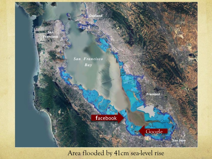
This image is based on a map produced by the San Francisco Bay Conservation and Development Commission
But this society is not going to just let nature take its course. Americans are too invested in the current users of the shore, and recently they have doubled down. Both Google and Facebook, the stars of Silicon Valley, have recently built immensely expensive headquarters on filled land in the path of rising tides. Both expect the public to defend their property at public expense.
Local environmental organizations use historical ecology to make a claim for a previous system that worked. Implicitly they also claim a voice for the everyday people of this place in managing the bayshore. But do environmentalists remember the inhabited bayshore, the human uses and purposes of the nineteenth century bay?
What has been eroded from our memories of the shoreline is that human bay, the many uses that an open access bayshore offered. Those older uses are layers of accreted history — marshes, oyster beds, salt mines, and wildlife refuge. Until it is an edible landscape once again, this place cannot be considered whole, or healthy.
If we cannot even visualize what that past looked like, it becomes much more difficult to imagine its future.
Originally published by Matthew Booker on June 11, 2012. Revised for the Journal of Digital Humanities September 2012.
Copyright for the images above by the Spatial History Project at Stanford University.